Wild Skies of Summer

 July 23rd
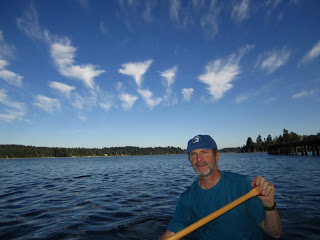
  Though it looks as if this man (my husband) is standing waist deep in a lake with a stick, he is actually in the stern of  our canoe, paddling furiously to escape the attack of these cloudy Valkyries.We'd all like a little more sun and heat right now, but I am glad for the clouds that have been enhancing the blue skies of the Pacific Northwest this summer. Blue skies just don't make very interesting photographs.
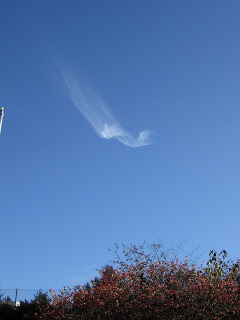
   Some of the strangest clouds I've seen so far are the cirrus uncinus (above) during a beautiful late-afternoon canoe trip on Henderson Inlet and Woodard Bay. These are high, wispy ice clouds and, from what I could tell, were forming in the eastern sky in the direction of Mt. Rainier. I couldn't see the mountain from the bay, but I could detect a distant layer of clouds from whence these strange tufts seemed to generate. Clumps of them rose from the east and "flew" across the sky, gradually dissipating as their icy tails lengthened and evaporated.   
July 29
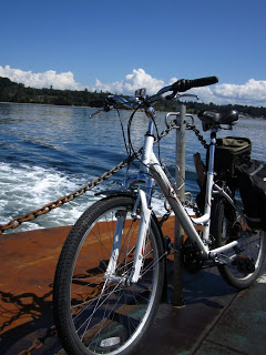
   Here is my bike, Cloud Chaser, (above) on board the ferry to Lummi Island. Thanks to the Whatcom County Transit System, we were able to take our bikes on the bus from downtown Bellingham to the ferry terminal at Pigeon Point ($7!). Our panniers and buckets held our clothes, birthday presents, a bottle of champagne, olives, cheese, and a baguette. Once off the ferry, we biked to the north end of the island to a yurt for the weekend. 
    Oh, but the clouds.The cumulus congestus rising over my handlebars, Bellingham, and the North Cascades remained low and distant. They did not do what they might have on the East Coast: continue their convective fury and turn into dark and stormy cumulonimbus.
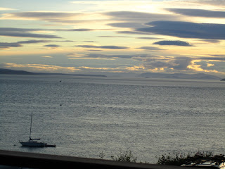
   At dinner one night, while we were grandly amusing our bouches, we had quite a spectacular show of altocumulus lenticularis, the lens-shaped clouds (below), over the Strait of Georgia. 

July 30
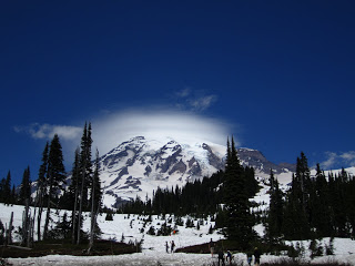
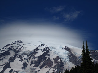
  The best show of all took place atop Mt. Rainier (below) where my father (visiting from the inferno of Washington, DC) and I planned to stroll amongst the alpine wildflowers and bask in the sun like marmots. Well, the trails at Paradise were still deep in snow and therefore closed to anyone without crampons and an ice axe. My dad and I wore sneakers just to make sure we didn't get corralled into some group summit climb.
August 2

August 2
  Happily, we strolled around in the sunny parking lot and just stared up at the mountain, looking through binoculars at the blue-ice crevasses of the Nisqually Glacier (in lower right quadrant of photo above) and watching the peak. While we were there, a distinctive cloud started appearing--a cap cloud--one most often seen on high mountaintops, especially isolated peaks. The cloud appears to be stationary, stuck on the peak like a cap on a head, but that is an illusion. Up close, you can watch the cloud forming on the windward side and dissipating on the leeward side. As air moves up the mountain flank, it cools and condenses. As it descends, it warms and evaporates. The cloud was continually "appearing" on our left and "disappearing" to our right in equal measure.  
August 4
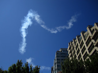
  And to top off two weeks of partly cloudy skies was this (above), the Cloud of Freedom produced by the Blue Angels during Seattle's annual Seafair. It is an artificial cloud, called a contrail, produced by condensation of warm moist air and particulate matter from jet-airplane exhaust. Great cloud, but unfortunately it is accompanied by the nerve-jangling, ear-drum-bursting Sound of Freedom.
    Me? I like my clouds silent and tyrannical.

Cloud of the Week # 4: Cirrus uncinus


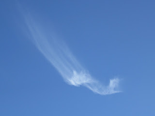
  Some of you may remember this cloud from an earlier "Accidental Naturalist" blog posting. This solitary cloud is an unusual form of a type of cirrus cloud called cirrus uncinus. 'Uncinus' (pronounced un-sun-us) means that the streaks falling behind the main clump of ice crystals are in the shape of hooks or commas. A common type of cirrus uncinus, one familiar to many people, are the 'mare's tails,' which, as you might expect, look like a horse's tail (mare or stallion, or even pony if you ask me).
   Unfortunately, I don't have any photographs of mare's tails and because I am trying to behave on the Internet, have chosen not to cut and paste someone else's photo in here. But here is a link.
  Not describing someone else's photo turned out to be a good thing for many reasons. It took me almost an hour (!) to select the three photographs posted here. Why? Because I am in the habit of turning my camera sideways to capture a scene vertically and I often forget to include a piece of landscape in the photograph. This is a problem when I want to post a sequence of photos to show the progression of a cloud over several minutes. I had posted some very wonderful cirrus uncinus, but had to delete them when I couldn't be sure I had the orientation and chronology correct. After I checked the time stamp on the images, I fixed the chronology problem, but then couldn't be sure up was up and down was down. One of my cirrus uncinus seemed to be doing cartwheels.
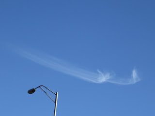
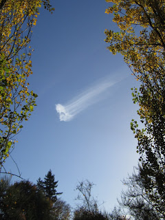
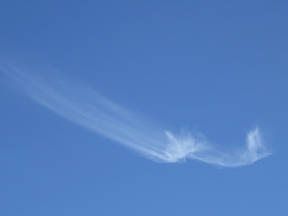
      The photo above and the two below are correctly sequenced and oriented thanks to some trees, bushes, what would otherwise be called an eyesore--a lampost.
   Because I was standing in the same place, I know that the cloud was moving west to east (right to left in the photos) and that the clumps were moving at a slower pace than the tails. Note that the tails get longer with each photo, indicating that they were trailing behind in slower, lower wind. This photo was hard to decipher because "behind" should be to the right, right? Yes, if the winds were blowing in a single direction throughout the troposphere. But they are not--and clouds are what show us they are not. I love this about clouds. They allow us to see the winds.
If you spend some time watching cirrus uncinus, you can watch the cloud age before your eyes. The ice-crystal tails will grow longer and longer with time and then dissipate altogether as the ice crystals evaporate. 

Lessons: When photographing clouds, don't zoom in so close that you can't figure out the relationship of the cloud to the earth. Always include a piece of landscape or even an unsightly structure you can crop out later. When photographing a single cloud, take several pictures a few minutes apart so you can see the subtle changes in the cloud's form.

The Answer My Friends...

   As promised, more on these unusual cirrus clouds I photographed a few weeks back and blogged about. I sent my photos to Art Rangno in Arizona for an explanation of the dramatic "tail" shifting (it did a 180-degree turn, from the 3 o'clock position to the 9 o'clock position as I watched it).
  Art Rangno has spent most of his life studying and loving clouds, 30 years of it as a meteorologist with UW's Department of Atmospheric Sciences in Seattle. He is an accomplished scientist in the field of airborne cloud studies and is the creative genius, photographer, and writer of the popular "guide to the sky" cloud posters, which got me hooked on clouds in the first place. Speaking of hooks....
The cirrus clouds above are called cirrus uncinus (hooked cirrus) and here is what Art knows about them: 
   
    Cirrus uncinus usually, as we think of it, has a hook, but it can also be a tuft at the top as in your first photo [below].
  
This would have happened many minutes before your first photo, likely over the horizon and out of view, as indicated by the length of the fallstreifen, aka, ice crystals.  At first, the formation of a cirrus uncinus is hard-looking, sharp edged dots and it has been suggested that they are water drops before almost instantly converting to ice (temperatures are generally below -30 C).  There must be some updraft to do create those specs, somewhat like in cumulus, but much more gentle, perhaps of the order of just a mile or two per hour.   One of the signs that there was an updraft with stronger and weaker portions is the stranding that shows different sizes of particles developed when the cloud formed. The different sizes are due to the differences in updraft velocities, the larger crystals forming where the updrafts were that bit stronger.  

They are formed, from time to time, out of the blue as something that would resemble a patch of cirrocumulus, a granulated cloud patch [below], though usually the granules are more splotchy. 
 At the stage you have photographed this cloud, they are usually "done", at least in their updraft stage, and now  the crystals are merely settling out from the original location, and as they do, you get to see how the wind changes with height, normally the crystals falling into regions of somewhat lower wind speeds below the "head" and leaving a comet's tail below.
The reason that they exist is that the air up there is likely saturated with respect to ice, or, below the head, very close to it.  The longer and lower the tail goes, the deeper the near ice-saturation layer.The crystals in these clouds are almost always bullet rosettes [below], BTW, ones that can get pretty large, and hence, fall relatively fast compared to the smaller crystals in haze like ice clouds such as a high veil of cirrostratus.
Photo courtesy Cal Tech
         

Curious Cirrus Get Curiouser

     I love the website of the U.K.-based Cloud Appreciation Society. Where else can you post photographs of Pacific Northwest clouds you don't understand before you go to bed and have your answer by the time you log in the next morning? 
   A few days ago, I posted here a blog titled Ice Comet?, which featured the strange behavior of the cirrus cloud (above) and my attempt to explain what was happening to it. I could not find a match for this particular comet-like cirrus in any of my cloud field guides or online resources. I understand the basics of cirrus formation in the upper atmosphere, but this one didn't fit any progression I had encountered.
     So, I posted my blog on the Cloud Appreciation Society's General Discussion Forum where thousands of cloud lovers around the world chat and share their observations and exquisite photos of clouds. I received this reply from some helpful someone:


A nice piece of observation, Maria, and well recorded. I am not an expert, but happy to offer some thoughts. As you suggest, it is Cirrus uncinus and I would suggest CH1.The RK Pilsbury photo coming closest to yours: http://www.metoffice.gov.uk/publications/clouds/ch1/eg2.html
   Yours is unique in my limited experience in having but one cloud, and one with a filament which is both rotating and in unusual directions.
   For CH1, Richard Hamblyn, The Cloud Book, says '... are usually formed when layers of relatively dry air ascend in the upper troposphere, the small amount of vapour then subliming into ice when it meets its subzero dew point...'.
   Thereafter the wind picks up the falling ice crystals and draws them into the filaments. I would hazard a guess that you must have some wind shear around that dew point boundary. 
  I do not know how to beginning thinking about "wind shear around a dew point boundary." The mind fairly boggles. Which is the beauty of clouds.I have sent photos of this cloud onto an actual meteorologist who lived and breathed Pacific Northwest clouds for thirty years.
  I will post his thoughts on this curious cirrus next week. Meanwhile...don't forget to look up.