 |
| It's easy to see why Cumulonimbus are called the King of Clouds. |
Cloud lovers, this week we are going to tackle a progression of cloud forms in the cumulus genus. I think you are ready to observe some of the subtle differences that distinguish one type from the next. So let's start with a cloud that's been visiting our early spring landscape here in South Puget Sound--the cumulonimbus. This cloud is also known as the thunderstorm cloud or the "thunderhead." For those of you cloudspotters who are also wine lovers (me! me!), the cumulonimbus is the meteorological equivalent of a bold zinfandel, whereas our earlier delicate cirrus species are on par with a pinot noir. The bases of these convective clouds can extend from 2000 feet above the ground to 60,000 feet or so--which means their tops are reaching the tropopause (the boundary of the troposphere where it meets the stratosphere). In 1896, this cloud genus was classified as cloud nine in the International Cloud Atlas as it was the highest cloud (cloud one being the lowly stratus). Being "on cloud nine" came to describe a state of great elation among us land-bound humans. The expression still has currency today despite the little-known fact that subsequent reclassification pegs the cumulonimbus at Cloud Ten.  |
| This is not a cumulonimbus cloud, it is a cumulus congestus. You can tell because it has the tight, cauliflower-like shape. |
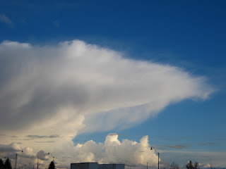
You can watch a cumulonimbus form in a matter of minutes. Keep your eye on the rapidly rising clouds that seem to be churning out their outer edges--a cloud that resembles the one pictured above. This is a cumulus congestus cloud. It is composed of water droplets and due to the convection within the cloud, it is growing rapidly and rising toward the top of the troposphere. And, because pressure and temperature generally decrease with elevation/altitude, the water droplets in this cloud will start to freeze as they continue to rise. As the water droplets become ice crystals, the well-defined edges of the cloud soften. Now this cloud, pictured below, is classsified as a cumulus calvus. Calvus means "bald," which will make more sense in a minute.
 |
| This is a cumulonimbus--a species called calvus. The cloud has lost its sharp edges. |
 |
| This is a cumulonimbus cloud--a type called capillatus. The lower "fringe" of this cloud is precipitation--rain or hail. |
Now, our cloud is a full-fledged cumulonimbus capillatus as its top loses all definition as the ice-crystals increase and give the cloud a fibrous or wispy, hair-like appearance at its edges (in contrast to bald, or calvus). Capillatus means "hair like" in Latin. (Trick for remember this: capellini is angel hair pasta.). Not only does our cloud get hairier, it flattens out as it reaches the upper boundary of the troposphere. This boundary, called the tropopause, limits the clouds growth. As our cloud flattens out, it becomes a tri-nomial: cumulonimbus capillatus incus. The word "incus" indicates is has the flat, anvil-shaped top.
 |
| This might be your view from beneath a cumulonimbus cloud. |
And because the clouds have been puring themselves down on us this past week, let's clear up nasty rumor about raindrops: they are not tear shaped. Small raindrops are actually spherical, like a ball. This is because a sphere is the shape that requires the least amount of energy for the drop to hold itself together.

As drops grow bigger than a millimeter or so, they start to become flat along their bottom edge as they fall, due to the resistance of air flowing around the drop. By the time a drop reaches 2-3 mm in diameter, it looks more like a hamburger bun than a sphere. Drops bigger than about 6 mm in diameter are relatively rare because the air resistance tends to cause the drops to breakup as they fall.
And speaking of big raindrops, the largest one ever observed was 8.8 mm (possibly even 1 cm!). This Guinness Book of Record holders was measured by UW scientists Art Rangno and Peter Hobbs over the Amazon Basin and Marshall Islands in 2004.
 |
| Big, hamburger-bun-shaped raindrops require big umbrellas. |

